|
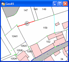
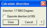
The direction is the angle between the horizontal axis and a line segment.
Supported object types: Line, Polyline, Polygon/Region, Rectangle, Collection

|
| • | The Layer must be selectable |
| • | The result can be cached with the Store button and be used/retrieved afterwards in some other MapCAD functions, such as Polar Append, Move and Rotate. |
|
| 1. | Select the Calculate Direction function. (The shape of the cursor changes to a crosshair cursor.) |
|