|
Create a line object using distance and angle
New Object: Line

|
| • | The Layer must be selectable |
| • | If an angle has been cached then you can retrieve this angle from the drop down list. |
|
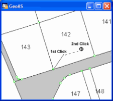
| 1. | Select the Polar Append function. |
| 2. | Digitize a 2-point construction line or make a single click at the starting point. |
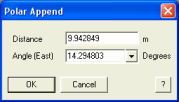
| 3. | Enter distance and angle. If an angle has been cached then you can retrieve this angle from the drop-down-list. |
|