Import (GIS/CAD)

Home  Zurück  Vor

Es stehen unterschiedliche Möglichkeiten zur Verfügung, externe Grafik-Formate zu öffnen.


GeoAS: Relation > Relation öffnen

MapInfo Pro: Datei > Öffnen

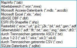
Formate_Import_Datei_öffnen


Direktzugriff auf die Original-Daten.

*.shp

ESRI Shapefile

*.ecw

*.sid

*.tif

*.jpg

und weitere ...

Rasterformate


GeoAS: Relation > Universelle Daten > Öffnen

MapInfo Pro: Datei > Universelle Daten öffnen

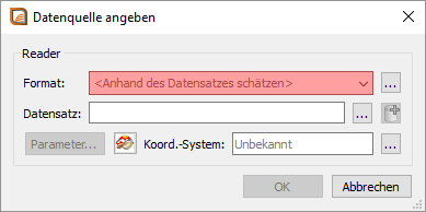
Formate_Import_Universelle_Daten_öffnen


Direktzugriff auf die Original-Daten.

*.dxf

*.dwg

Autodesk AutoCAD

*.dgn

Bentley MicroStation (Version 7, Version 8)

*.e00

ESRI ArcInfo

*.gdb

ESRI Geodatabase

*.gml


*.kml

*.kmz

Google Earth


GeoAS: Relation > Import Export > Universal Translator

MapInfo Pro: Werkzeuge > Universal Translator


Die externen Daten werden beim Einlesen dupliziert und im MapInfo-proprietären *.tab-Format gespeichert.


Autodesk AutoCAD DWG/DXF (.dxf, .dwg) — up to AutoCAD rel 2013


Bentley MicroStation Design 7 (.dgn)

Bentley MicroStation Design 8 (.pos, .fc1, .dgn)


ESRI ArcInfo Export (.e00)

ESRI ArcSDE

ESRI Geodatabase (Personal Geodatabase) (.mdb)

ESRI Shapefile (.shp)


Google Earth KML (.kmz, kml)


Spatial Data Transfer Standard, such as TR01CATD.DDF (*CATD.DFF)


Vector Product Format (VPF) Coverage, such as POAREA.AFT, POLINE.LFT, POPOINT.PFT (.*ft)


Methode und Charakteristik

Formate

GeoAS: Relation > Import Export > Import

MapInfo Pro: Relation > Importieren

Formate_Import_Import


Die externen Daten werden beim Einlesen dupliziert und im MapInfo-proprietären *.tab-Format gespeichert.

*.mif (*.mid)

MapInfo Interchange Format (MIF)

proprietäres ASCII-Format von MapInfo Pro

*.dxf

AutoCAD DXF

The graphic/data interchange format (DXF) for AutoCAD and other CAD packages

*.mbi

MapInfo DOS MBI

MapInfo Boundary Interchange Format (MBI).

Eine ASCII-Datei für MapInfo DOS boundary files.

*.mmi

MapInfo DOS MMI

*.img

MapInfo DOS Image

Eine Dateiformat für MapInfo Pro für DOS image files

*.gml

OS MasterMap

*.gml / *.xml

Geography Markup Language 2.1